Record-Breaking Flash Floods Submerge Border Towns
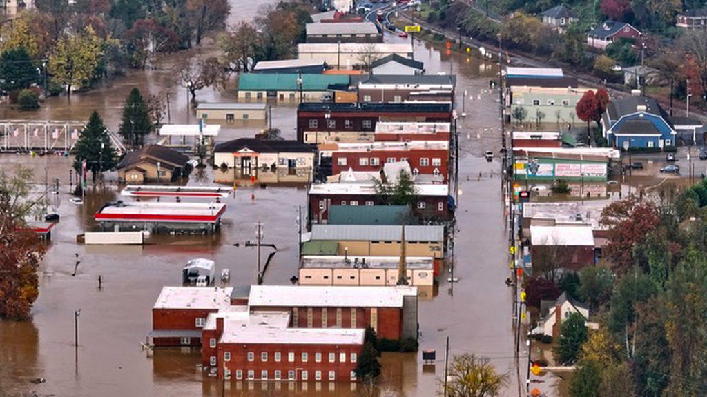
The mountainous terrain along the Georgia-Tennessee border has turned into a dangerous landscape of rising water and stranded residents following a deluge of rainfall that began late Wednesday night. By Thursday morning, the communities of McCaysville, Georgia, and Copperhill, Tennessee, found themselves at the center of a life-threatening flash flood emergency, with water levels reaching heights that local officials say are unprecedented in their professional lifetimes.
The National Weather Service (NWS) recorded up to five inches of rain in McCaysville alone. However, meteorological data reveals that some pockets across Fannin and Gilmer counties saw rainfall totals as high as 11 inches within a narrow 20-by-10-mile corridor. This extreme concentration of precipitation, arriving overnight when many residents were asleep, caught the region largely off guard.
(November 5, 2026 | 8:25 a.m. CT): The Tennessee State Emergency Operations Center has been activated to a Level 4 due to the flooding that has occurred in Polk County. At this time, the flooding is expected to remain through this evening. Please avoid flooded roads and follow… pic.twitter.com/ZInDbD2Qmw
A Night of Rapid Rescue Operations
The human toll of the flooding became clear as the sun rose on Thursday. McCaysville police chief Michael Earley described the scene as the most severe he has ever witnessed, noting that water in certain areas surged to six or seven feet high. By mid-morning, first responders had conducted more than 30 boat rescues, a figure that local reports later adjusted upward to more than 50 as the day progressed.
“I’ve never seen flooding like this in my life,” said McCaysville police chief Michael Earley, as reported by WSMV.
The situation was complicated by a series of overlapping emergencies. Robert Poole, a spokesperson for Fannin County emergency management, explained that local resources were already stretched thin due to multiple structure fires sparked by lightning as the storm front moved in. As the rain intensified, those fires were compounded by urgent water rescues. In one harrowing instance, responders were forced to switch from firefighting to locating a driver who had been swept away in his vehicle, highlighting the NWS warning: "Turn around, don't drown when encountering flooded roads. Most flood deaths occur in vehicles.”
57 people we're rescued by Swift Water Rescue teams in Fannin County last night and early this morning. The McCaysville Police Chief said there were no injuries that he's aware of. This is incredibly good news! The water level is dropping now. pic.twitter.com/HKJpkfGZcW
The Meteorological “Why” Behind the Deluge
The severity of this event is rooted in the unique geography of the southern Appalachians. As a cold front pushed through the region on the evening of November 4, 2026, a band of showers and thunderstorms stalled over the area. Instead of moving through quickly, these cells remained stationary for several hours, dumping rain at rates of two to three inches per hour. This rapid accumulation on steep, mountainous terrain forced water into creeks and rivers—specifically the Toccoa and Ocoee—far faster than the land could absorb it.
The impact was record-setting. Weather data indicates that the flood crest observed in Copperhill, Tennessee, early Thursday morning surpassed the all-time record in 80 years of records. For residents and business owners in these twin towns, the economic and structural implications are only beginning to surface, with authorities already issuing a boil water advisory for McCaysville.
Georgia Governor Declares Emergencies to Deploy Rescue Assets
Georgia Governor Brian Kemp has declared official emergencies in four counties, a move designed to unlock additional state resources and facilitate the deployment of aviation and boat assets. The Georgia Department of Natural Resources has also integrated game wardens into the search-and-rescue teams currently operating in Fannin and Murray counties. While the rain has stopped, local officials are warning against complacency.
The agency issued a stern reminder via social media on Thursday: “Please do not let the rain stopping give you a false sense of security.” Floodwaters in this region are known to remain hazardous long after the clouds clear, and with roads in Fannin and Gilmer counties rendered impassable, the infrastructure recovery process will likely be a slow, multi-day endeavor. For now, the priority remains the safety of those still trapped or displaced by the rising Toccoa River.
I’ve declared a state of emergency for Fannin, Gilmer, Murray, and Union Counties following the flash flood emergencies that occurred overnight. As emergency personnel continue to respond, this will ensure all necessary resources are available to assist these communities impacted…
More on Tennessee
The state is actively responding to the flooding in NW Georgia. @GeorgiaEMAHS is leading a multi-agency response including @ga_dps and @GaDNRLE, using both aviation and boat assets, as well as local counties and Tennessee first responders. This is an ongoing flash flood…
Flash Flood Emergency including Ducktown TN until 7:00 AM EST pic.twitter.com/0R69LAHQX2
The Toccoa / Ocoee River at Copperhill has crested at just over 18 ft this morning. However, it will take quite some time for the flood waters to recede. Please continue to exercise extreme caution and follow orders of local emergency management and law enforcement officials. https://t.co/D2ZUDqis3U pic.twitter.com/3bRW126cJ2