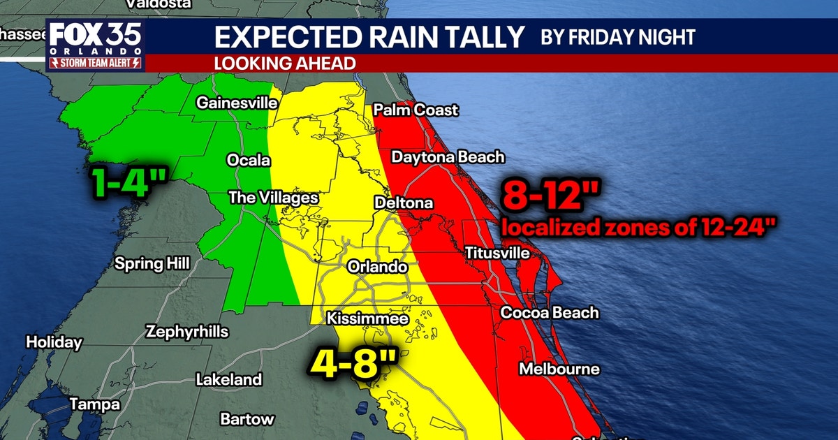
“Over the course of Tuesday through Thursday, there could certainly be widespread rainfall amounts of 2 to 4 and even 4 to 8 inches across much of eastern and southern Florida, with localized amounts over a foot possible where the heaviest storms move slowly for extended periods of time,” meteorologists warned as a multi-day deluge began to submerge parts of the state’s Atlantic coast.
The National Weather Service has issued a flood watch that remains in effect for a broad swath of southeast Florida, including Coastal, Metro, and Inland Palm Beach, Broward, and Miami-Dade counties.
The heavy rainfall, which began early this week, has triggered flash flooding across Southeast Florida, leaving streets underwater and forcing school closures. In Hollywood, where some areas recorded more than 14 inches of rain in 24 hours, the intensity of the storm led to a partial roof collapse at a local synagogue.
11/18 – Here's a preliminary look at 24-hour rainfall totals across the hardest hit parts of Broward County. Peak values range between 12-15 inches of rain. pic.twitter.com/pYwRGxirvW
Emergency management officials and the National Weather Service have issued flood watches along the I-95 corridor from St. Augustine to Palm Beach, warning that the ground remains saturated from historic rainfall that hit the region earlier in November.
Broward Schools Close Wednesday; Palm Beach Stays Open
As conditions worsened on Tuesday, the Broward School District announced that all schools and district offices would remain closed on Wednesday.
11/17: Heavy rainfall is expected across Florida, bringing a slight to moderate risk of flash flooding along the East Coast through Saturday. ⚠️ Flood Watches: Brevard, Broward, Indian River, Martin, Miami-Dade, Okeechobee, Orange, Osceola, Palm Beach, Putnam, Seminole, St.… https://t.co/Rw2eEx9a4R pic.twitter.com/R53JuPpHBt
Sean Cooley, chief of communications and enrollment for the Palm Beach County School District, confirmed that their district offices and schools would remain open Wednesday, though other districts across the Treasure Coast were modifying schedules. In Broward, officials said that the excessive moisture and street flooding created treacherous conditions for travel.
Chuck Caracozza, a lead weather service meteorologist in Miami, reminded drivers to “turn around” and not drive through flooded streets, advising the public to “take it slow and keep your headlights on.” The South Florida Water Management District stated it is managing its canal systems to allow the flood control network to operate at full capacity.
More rain is expected this week. If you were impacted by the recent flooding, make sure to report your damage. Recovery information: https://t.co/HLAapzdvYlhttps://t.co/qg5tUZRYfX
Officials further warned that debris and trash cans should be secured to prevent them from blowing into drainage ways, and explicitly cautioned residents not to wade or swim in floodwaters, which may hide unseen dangers.
The National Weather Service has maintained a Level 3 out of 4 flood risk for much of the Atlantic coast through Friday. The heaviest rainfall is expected between Jacksonville and Port St. Lucie. The FOX Forecast Center said that the Level 3 threat extends nearly 200 miles, stretching from Fernandina Beach to Palm Bay.

In Melbourne, where Jim Cantore of The Weather Channel is broadcasting, residents are bracing for potential totals of up to a foot or more of rain, which could put the city within range of its rainiest year on record.
| Location | Forecasted Rainfall |
|---|---|
| Coastal Flagler & Volusia | 8–12 inches (localized up to 24) |
| Metro Orlando | 4–8 inches |
| Palm Beach County | 2–4 inches (isolated up to 10+) |
| Inland Central Florida | 1–4 inches |
Atmospheric Drivers and Future Outlook
The current weather pattern is being influenced by a stalled low-pressure system lingering over the Gulf and eastern Atlantic. This system is continuously funneling moisture over the state. According to the FOX Forecast Center, the system brings atmospheric conditions similar to the event that produced historic flooding in Brevard County earlier this month.
The region is also under the influence of El Niño, which forecasters warn is driving major shifts in the winter weather season. This pattern amplifies the subtropical jet stream, which acts like a train track for storms moving from the Pacific into Florida.
Heavy to excessive rainfall will likely bring flash and urban flooding impacts along the I-95 corridor from St. Augustine to Palm Beach, Florida through this weekend. Keep an eye on https://t.co/o5cxJlONPR for the latest, and Turn Around, Don’t Drown. pic.twitter.com/BikTUpvJyi
Brevard County residents have been preparing for the influx of water, with three sandbag distribution sites opened across the county. In the Titusville community, La Cita HOA President David Bennett reported that residents contacted city officials to prepare for the rain, noting that the area had flooded earlier this month with water affecting Raney Road and the Country Club.
Across Central Florida, the First Warning Weather team—including Chief Meteorologist Tony Mainolfi, Eric Burris, Cam Tran, Victoria Wisniewski, and Luke Vickery—has been tracking the system as it moves toward the Space Coast.
Looking ahead, drier weather is expected to return this weekend as the low-pressure system shifts north. Rain chances are expected to subside by Saturday and Sunday, though the timing for the return of more significant moisture remains uncertain for the following week.


